Tuesday, 9 September 2014

Chocolate Hills in Philippines by thetravelboss.com


No, they are not really made of chocolate, but they do look good enough to eat. Some people can't believe they are just the work of Mother Nature and that man played no part in their creation, but that is probably why they are so unique.

The Chocolate Hills get their name from the brown-colored grass that covers them during the dry season, which makes them look good enough to eat. The rest of the time they are just as green as the forest that surrounds them. There are 1,268 cone-shaped hills spreading across 50 square kilometers, in the middle of Bohol Island.

Geologists from all over the world came up with different theories about how these perfect limestone cones were formed, but so far no one can really say for sure. The most widely accepted theory is that the Chocolate Hills were once coral deposits that rose up from the sea during a huge geologic shift. The shapes we see today were molded by winds and erosion over hundreds of years.

Just like most of natures masterpieces, the Chocolate Hills have legends passed on by the locals, from generation to generation. The most popular one tells of two rival giants who threw rocks and boulders at each other for days. Exhausted, the giants forgot about their meaningless conflict, became friends and left the island without cleaning up the mess they made. The hills are testimony of their great battle. Another myth tells the story of Arogo, a young, powerful giant who fell in love with Aloya, a mortal girl. When she died, Arogo shed thousands of tears and when they dried up, they formed the Chocolate Hills.

They may look like just a bunch of hills to some people, but they managed to put Bohol Island on the international tourist map long before its hot, sandy beaches became so popular. People travel from all over the world just to gaze at the spectacular scenery offered by the seemingly infinite number of hills. The fact that they are all about the same size (between 30 and 50 meters) and shape makes the view even more surreal.

Puerto Princesa Underground River in Philippines by thetravelboss.com

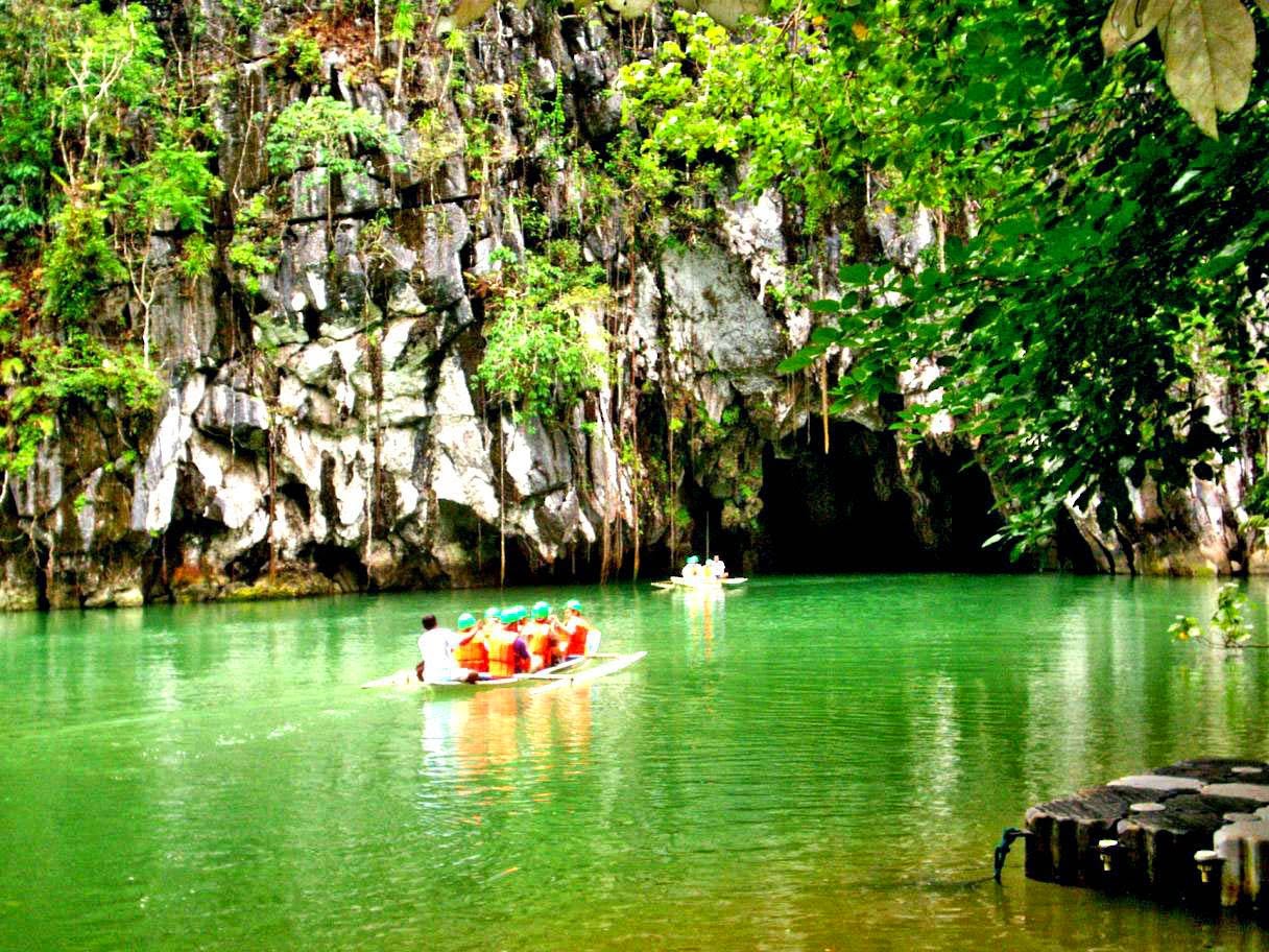
The site of the Puerto-Princesa Subterranean River National Park is located in the Saint Paul Mountain Range. It is north-west of Puerto Princesa, the capital of Palawan Province. The topography varies from flat plains to rolling hinterlands and hills to mountain peaks. Over 90% of the park comprises sharp, karst limestone ridges around Mount St Paul, which is itself part of a series of rounded, limestone peaks aligned on a north-south axis, along the western coast of Palawan.

The focus of the area is a spectacular karst landscape which features both surface karst features (pinnacles, shafts, dolines and limestone cliffs), as well as an extensive underground river system. The subterranean river is 8.2 km long, one of the most unique of its type in the world and includes many speleotherms, several large chambers exist, up to 120 m wide and 60 m high. A distinguishing feature of the river is the fact that it emerges directly into the sea, and that the lower portion of the river is brackish and subject to tidal influences.

The underground river (the Cabayugan River) arises approximately 2 km south-west of Mount Saint Paul at an altitude of 100 m, and flows underground for almost its entire length to an outflow into St Paul's Bay. All rivers and associated tributaries are within the park, which is important in relation to catchments impacts on the water quality of the Cabayugan River.

 Approximately two-thirds of the site is forested, dominated by hardwood species. Three forest formations are present: lowland, karst and limestone. The karst forest is restricted to small pockets where soils have developed. In the coastal area, mangroves, mossy forest, seagrass beds and coral reefs are also found.

The faunal diversity in the park is moderate, especially with respect to invertebrates. Endemic mammals include the Palawan tree shrew, Palawan porcupine and Palawan stink badger. Dugong has been recorded in the marine component of the park. Monitor lizard and marine turtles are also present. The Palawan Peacock Pheasant has also been recorded in this site (recognized as an internationally threatened species). The subterranean fauna has not been studied in detail, but comprises fish, prawns, snakes and insects. The tunnel and chambers of the subterranean river are home to abundant populations of swiftlets and bats. Eight species of bat are also found in the cave, and cave swiftlets nest on some of the underground boulder piles. Further studies are required to determine the extent and diversity of the underground fauna.

Puerto Galera in Philippines by thetravelboss.com

Puerto Galera is a soothing vision of shimmering seas surrounded by lush mountains. It is considered one of the most beautiful and developed beach resort community in the country.

Starting from "backyard tourism" wherein local residents accept local and foreign tourist as stay-in guest, the island’s tourism has flourished. In the course of time, several hotels, resorts, inns and restaurants have mushroomed within the area.

There are a thousand things one can do here. Landlubbers can pitch tents, light bonfires, play volleyball, toss a Frisbee, go beach-hopping, watch the sunset, gaze at the stars, hike, go rock climbing, carom off on a motorcycle, discover Oriental Mindoro’s other tourist spots or simply live it up.

But water is certainly the main attraction of the island. Crystal clear and shimmering especially during the hot summer months, the sea framing Puerto Galera is ideal for swimming, sailing, surfing, snorkeling and scuba diving. In fact one doesn’t have to go by boat to get to a dive site. Within a kilometer from the coast, schools of Moorish idols, trumpet fish, frog fish, lion fish and leaf fish weave in and out of thriving corals and sea anemones while species of starfish – from the speckled red-and-white to the neon-blue Pacific – rest on the sandy floor.

Gradually sloping beaches – with the terrain ranging from powder white sand to grainy dark sand to smooth stones to rough coral rubble – comprise a large chunk of the island’s 25 thousand hectares. And while the Department of Tourism’s last count pegs the number of resorts at 115, pockets of isolated and virtually resortless coves and beaches are tucked between massive rock formations.

Outside of minor glitches, Puerto Galera is a tropical paradise that is both rustic and thriving. By day it echoes with the soft breeze and the pounding waves. At night, it comes to life with heady laughter and the clink of wine and glasses, only to segue once again to the barest whisper of the elements.

Malapascua Island in Philippines by thetravelboss.com

This little island off Cebu's northern tip has been growing steadily more famous over the years for its long, white beaches, great food and low-key approach to tourism. There are, or were at the time of writing, no cars or paved roads on the island, only a network of walking tracks. These tracks wind past such humble attractions as the waterside town cemetery, with its sun-bleached graves, the lighthouse on the island's northwest, and the 12m-high lookout up near Los Bamboos, which some brave/foolhardy souls treat as a cliff jump.

Divers are spoilt with three wreck dives, the marine sanctuary of Gato Island - a famous sea-snake breeding ground - and almost daily appearances of the otherwise rarely sighted thresher shark off Monad Shoal.

The simple villages of Malapascua blend seamlessly with the resorts and are a big factor in the island's charm. The people of the towns are almost invariably friendly and welcoming. A popular pastime among visitors is to head down to the basketball court in the main town of Logon, to take part in one of the frequent, informal tournaments that blend local and foreign talent.

It would seem that Malapascua offers everything that the discerning beach bum could wish for. But of course nothing is ever that simple.

The marine environment, including Gato Island, faces the usual challenges of this region - first and foremost, dynamite fishing. Despite protestations from local government that they are on top of the problem, divers report that on many dives they can still hear the sound of blasting. To combat the problem at Gato Island, local dive centres successfully lobbied the government to implement full-time patrols of the marine sanctuary. These patrols are paid for by a fee levied on divers of P100 per dive.

The preservation of the island environment is another matter. Ironically, where the dive centres have continually accused local government of not doing enough to halt destruction of the corals, when it comes to preserving the beaches, it's the government's turn to put the heat on local business.

Monday, 8 September 2014

San Agustin Church in Manila by thetravelboss.com

San Agustín Church is the oldest existing church in the Philippines. It is an essential tourist destination in Manila for those who are interested in Philippine history and culture.

The present structure is actually the third to stand on the site. It has 14 side chapels and a trompe-l'oeil ceiling. Up in the choir loft are the hand-carved 17th-century seats made of molave, a beautiful tropical hardwood.

The San Agustín Church lies inside the walled city of Intramuros located in the capital city Manila. It is the first European stone church to be built in the Philippines designed in Spanish architectural structure. It also houses the legacies of the Spanish conquistadores, Miguel Lopez de Legazpi, Juan de Salcedo and Martín de Goiti who are buried in a tomb underneath the church.

Located in the historic Intramuros district of Manila (the oldest district and historic core of Manila, otherwise known as the "Walled City"), the Church of San Agustin was designated an UNESCO World Heritage Site as an example of the Baroque architecture that was specific to the Philippines. A Roman Catholic Church, it was constructed by the Spanish in the sixteenth century, but was not consecrated until 1607. Its beautiful architecture is worth the visit all by itself, though it also houses the tombs of several historical figures, including several conquistadors, statesmen and artists.

The accompanying San Agustin Museum is housed in the adjacent San Agustin Monastery, and exhibits art and artifacts from the Philippines, Spain, Mexico and other cultural centers. The original Augustinians arrived in the Philippines in 1565 just a few decades after Magellan explored the islands, meaning that the aforementioned museum is no slouch. Despite having been damaged by British forces in the 18th century, American forces in the 19th century, and the Japanese in the 20th, it’s in fine fettle (partially owing to a painstaking restoration effort undertaken in the 1970s). If you’re interested in local and regional history, you won’t want to miss it.

Entry into the Church of San Agustin is free. The museum charges 100 PHP for adults, 80 PHP for seniors, and 40 PHP for children. There are also discounts for college and high school students, so be sure to inquire about pricing upon your arrival. The websites for both attractions offer up-to-date listings of upcoming special events. San Agustin is located on General Luna Street, and is open 8am to noon and 1pm to 6pm daily.

Tubbataha Reef in Philippines by thetravelboss.com

Tubbataha Reefs Natural Park lies in a unique position in the centre of the Sulu Sea, and includes the Tubbataha and Jessie Beazley Reefs. It protects an area of almost 100,000 hectares of high quality marine habitats containing three atolls and a large area of deep sea. The property is home to a great diversity of marine life. Whales, dolphins, sharks, turtles and Napoleon wrasse are amongst the key species found here. The reef ecosystems support over 350 species of coral and almost 500 species of fish. The reserve also protects one of the few remaining colonies of breeding seabirds in the region.

Tubbataha Reefs Natural Park contains excellent examples of pristine reefs with a high diversity of marine life. The property includes extensive reef flats and perpendicular walls reaching over 100m depth, as well as large areas of deep sea. The remote and undisturbed character of the property and the continued presence of large marine fauna such as tiger sharks, cetaceans and turtles, and big schools of pelagic fishes such as barracuda and trevallies add to the aesthetic qualities of the property.

Tubbataha Reefs Natural Park lies in a unique position in the middle of the Sulu Sea and is one of the Philippines’ oldest ecosystems. It plays a key role in the process of reproduction, dispersal and colonization by marine organisms in the whole Sulu Sea system, and helps support fisheries outside its boundaries. The property is a natural laboratory for the study of ecological and biological processes, displaying the ongoing process of coral reef formation, and supporting a large number of marine species dependant on reef ecosystems. The presence of top predator species, such as tiger and hammerhead sharks, are indicators of the ecological balance of the property. The property also offers a demonstration site to study the responses of a natural reef system in relation to the impacts of climate change.

Tubbataha Reefs Natural Park provides an important habitat for internationally threatened and endangered marine species. The property is located within the Coral Triangle, a global focus for coral biological diversity. The reefs of the property support 374 species of corals, almost 90% of all coral species in the Philippines. The reefs and seas of the property also support eleven species of cetaceans, eleven species of sharks, and an estimated 479 species of fish, including the iconic and threatened Napoleon wrasse. The property supports the highest population densities known in the world for white tip reef sharks. Pelagic species such as jacks, tuna, barracuda, manta rays, whale sharks and different species of sharks also are common here and the property is a very important nesting, resting and juvenile development area for two species of endangered marine turtles: green turtles and hawksbill turtles. There are seven breeding species of seabirds and Bird Islet and South Islet are breeding grounds to seven resident and endangered breeding species of seabirds. The critically endangered Christmas Island Frigatebird is a regular visitor to the property.

Integrity

The property comprises two atolls (North and South Atoll) and an emergent coral cay, Jessie Beazley Reef. It includes open sea with an average depth of 750 m and still displays a well preserved marine ecosystem with top predators, and a large number and diversity of coral reef and pelagic species. The property also hosts an important population of resident, nesting and feeding seabirds. The area is free of human habitation and activities and is of a sufficient size to maintain associated biological and ecological processes. The property is of an adequate size to ensure the complete representation of the key features and processes of the reef systems within it, although the maintenance of these values also requires measures to be taken outside the boundaries of the property in relation to some migratory species and the buffering of the property from threats to the marine environment that could occur in the wider area. A key aspect of the integrity of the property is the low level of fishing pressure, due to the no-take policies which are in place throughout its area.

Management and protection requirements

Tubbataha Reefs Natural Park is legally protected through national protected areas legislation and a range of other environmental legislation which enable action to be taken against a wide range of threats. The implementation of the legislation is assisted by clear delegation to the management authority for the property. This is a remote property and its management is therefore a significant logistical challenge, requiring a well-equipped team with operational boats, well trained and well equipped staff and a sufficient operating budget for fuel, maintenance and accommodation to ensure a strong and responsive presence on the water. Tourism visitation requires careful planning and management to ensure the values of the property are maintained, and to respect the capacity of the property, as well as visitor safety and to ensure income is returned to both site management and local communities. There are threats to the property from shipping, marine litter, fishing, marine pollution and oil exploration. Thus effective buffer zone arrangements are needed, and internationally supported legislation to protect the property from shipping threats, and greater enforcement of marine litter regulation on the High Seas by the appropriate international organisations would be a significant benefit to the property.


Partner Sites

Important Links

 
Blogger Templates